Lakefront Property Owners Help Collect Sediment Core Samples From Kezar Lake, Lovell, Maine
Out and About for the Sebago Lakes Region of Maine Mar. 12-18
March 11, 2015Out and About for the Bangor Lakes Region of Maine Mar. 19-25
March 18, 2015Lakefront Property Owners Help Collect Sediment Core Samples From Kezar Lake, Lovell, Maine
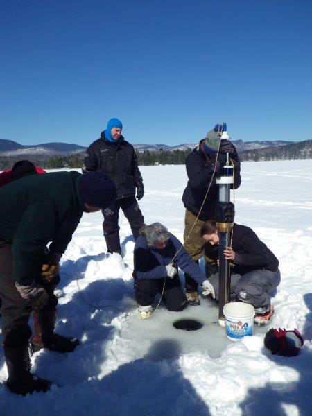
photo credit:Lucy LaCasse
Gathering a Sediment Core Sample on Kezar Lake, Lovell, Maine
Lucy LaCasse of Stoneham, Maine, shared with us this information about collecting a sediment core sample from the bottom of Kezar Lake in Lovell.
“The coring effort, organized by the Kezar Lake Watershed Association’s Climate Change Observatory, is a collaboration with Dr. Lisa Doner at Plymouth State University (PSU), New Hampshire. Doner is a paleolimnologist (the study of past changes in lake environments) in the Department of Environmental Science and Policy and a researcher at PSU’s Center for the Environment. With the logistical and moral support of 26 volunteers from the Kezar Lake area, Doner and five PSU students transformed our normal weekend routine into an actual scientific field expedition.
The goal of the project is to determine, using information stored within the sediments, how Kezar Lake has been affected over time by environmental impacts, natural and otherwise. We collected three “short cores” ranging in length from 15-20,” each of which should produce about 150-250 years of sediment history. It is hoped that these samples will shed light on the impacts that Colonial sheep farming, major weather events, historic timber harvests, lakeside development and dredgings, and conservation efforts have had on Kezar Lake.
The results should be fascinating. We may even see a signature of radioactive fallout from the Chernobyl accident in 1986. And, moving forward, the knowledge we gain from these sediment cores can help inform decisions about how we manage the watershed in the face of increased intense storm events due to climate change, future lakeside development pressures, and proposed timber harvests, etc.
So how and where did we collect these sediment core samples? Gathering at Kezar Lake’s north end, dozens of enthusiastic volunteers and sleds full of equipment were shuttled on six snowmobiles to the lake’s deepest waters, about one mile to the south. Drilling a hole through the 18” thick ice, our depth finder read 153’. With the theory that most sediment will settle in the lake’s deepest areas, this location was perfect.
Once the core sampling apparatus was assembled with its five-foot plexiglass tube, brass collar, steel braces and plunge-ball capping mechanism, it was lowered by rope down through the ice. The line had been measured so we’d know when the sampler was approaching the bottom. At that point, the mechanism was released in a controlled but fast drop, allowing gravity to drive the hollow tube deep into the soft muddy substrate 153 feet down.
After letting the tube settle for a few seconds, the mechanism was gently hauled up with 52 centimeters of black muck securely trapped in the tube. Doner thought this likely represents the lake’s history from the present back to pre-Colonial times. It was essential to keep the tube upright after retrieval, because any shifting of sediment would negate the intact snapshot of geological history. This is a primary reason to collect core samples in the winter: a lake’s frozen surface is much more stable than that of a rocking boat. In these deepest spots, it’s very hard to anchor a boat securely enough for successful core collection.
After removing the plastic tube from the collection apparatus, it was tenderly transferred, still upright, to a portable ice-shack for processing. There, using a specially designed holder, the core was cut in much the same way cheese or meat is cut at the butcher counter. The mud was pushed up the tube, from the bottom, and one half-inch thick sections were sequentially sliced off the top as it popped out of the tube. Each slice, representing a small period of time in history (usually about 5-10 years), was placed into containers and labeled according to core depth. The slicer was cleaned with distilled water between each cut to avoid any contamination between layers. At Plymouth State, the sediment layers will be analyzed to determine organic content, age, magnetic susceptibility, and mineral composition, among other things. It will be fascinating to discover the mud’s story.”
LaCasse continues, “After lunch the group collected a final sediment core sample near the mouth of Great Brook, the source of approximately one third of Kezar Lake’s water. Here, the lake was 33 feet deep, and the core sampling went fairly quickly. Upon the core’s retrieval, Doner pointed out a layer of woody debris about 5 inches down from the top of the sediment. This may have been from the old marina’s dredging in the 1970s or some other event. There is much to learn and the cores will help tell the stories …”
To learn more about lakefront property for sale on Kezar Lake, click on the green box above.
To learn more about Kezar Lake and the Lovell area of western Maine, check out the blog links below.
Kezar Lake, Lovell, Maine: Pristine Lakefront with Stunning Mountain Views
Ebenezer’s Pub in Lovell, Maine – Where Kezar Lakers Go For Beer and Hospitality