Hikes In and Around Rangeley, Maine
Road Associations Important to Maine Lakefront Property Owners
June 6, 2013
Out and About for the Bangor Lakes Region of Maine June 13-19
June 12, 2013Hikes In and Around Rangeley, Maine
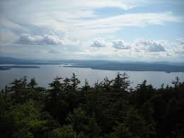
Breathtaking Beauty Awaits in Rangeley, Maine
The picturesque landscape of Rangeley, Maine, sets the stage for outdoor activities. Mountain breezes take the edge off a hot summer day. Sparkling lakes and ponds, cascading rivers and streams and plummeting waterfalls enhance the experience. The landscape is ever changing.
And then there’s the moose watching. Bring your camera! Not only is the countryside picturesque, but the wildlife is abundant. It’s not uncommon to see moose, deer, black bears and other wildlife. And listen for the call of the loon.
ANGEL FALLS:
Scenic “hanging” falls with 90-foot drop. Return via the same trail.
Trailhead: Bemis Road, Byron
Degree of Difficulty: moderate to difficult
APPALACHIAN TRAIL:
Several choices–trail from Route 17 to Route 4 is approximately 13 miles, from Route 4 to the summit of Saddleback Mountain is 5 miles (find Piazza Rock–a fun destination for young hikers, about 1.4 miles from Route 4, plus a side trail off of Saddleback Mountain, to the base lodge.
Trailhead: Beech Hill Road, Rangeley; Route 17, Roxbury
Degree of Difficulty: Moderate
AZISCOHOS MOUNTAIN:
A 1.75-mile hike to the summit on the Firewarden’s Trail offers spectacular lake views. Return via the same trail.
Trailhead: Route 16, Lincoln Plantation
Degree of Difficulty: Easy
BALD MOUNTAIN TRAIL:
A 1.75-mile hike to the summit, where you can climb the new 30-foot lookout tower and enjoy panoramic mountain and lake views. Picnic tables at the summit. Return via the same trail.
Trailhead: Bald Mountain Road, Oquossoc
Degree of Difficulty: Moderate
CASCADE STREAM GORGE TRAIL:
A short hike with plenty of opportunities to view the 2000-foot rocky gorge, dotted with pools up to 90-feet deep and a 16-foot waterfall. Picnic tables are available along the way. Return via the same trail.
Trailhead: Town Hall Road, Rangeley
Degree of Difficulty: Easy, but steep terrain
FOREST LEGACY TRAIL:
Access via water or land for this 5-mile loop along the ridgeline and shoreline.
Trailhead: via water from Haines Landing, Rangeley or Wilson Mills Road, Rangeley
Degree of Difficulty: Easy to Moderate
HATCHERY BROOK TRAIL:
One-mile loop with picnic sites on Rangeley Lake.
Trailhead: Manor Road, Rangeley
Degree of Difficulty: Easy
HUNTER COVE WILDLIFE SANCTUARY:
A network of trails for wildlife viewing has been made possible by the Maine Audubon Society.
Trailhead: Dodge Pond Hill, Route 4, Rangeley
Degree of Difficulty: Easy
MINGO SPRINGS TRAIL AND BIRD WALK:
The Mingo Springs Golf Course maintains a 2-mile trail through various forest types with excellent wildlife viewing.
Trailhead: Mingo Loop Road, Rangeley (park on left next to golf course maintenance building)
Degree of Difficulty: Easy
MOUNTAIN POND:
A 1.5-mile trail leads uphill to the edge of Long Pond. Return on the same trail.
Trailhead: South Shore Drive or Edelheid Road at Utility Pole #13, Rangeley
Degree of Difficulty: Moderate
RANGELEY LAKES TRAILS CENTER
Hikers and mountain bikers enjoy the seven miles of trails. Difficulty rating for mountain bikers: 2 miles are easy (to steel bridge and back along Tote Road). The remainder is suggested for advanced mountain bikers.
Trailhead: 524 Saddleback Mountain Road, Rangeley
Degree of Difficulty: Easy to Moderate
ROUND TOP TRAIL
A 1.2-mile trail leads to Quimby Pond. Return on the same trail.
Trailhead: Dodge Pond Road, Rangeley
Degree of Difficulty: Easy
SADDLEBACK MOUNTAIN :
Two mile hike from the base lodge to the summit. Ski trail maps and a recommended route are available at the base lodge. Also assessable via the AT.
Trailhead: Saddleback Mountain Road
Degree of Difficulty: Moderate
SMALLS FALLS:
The short trail parallels Sandy River and Chandler Mill Stream and offers views of the 54-foot falls, plus swimming and wading pools, picnic tables, grills and restrooms.
Trailhead: Route 4, Franklin
Degree of Difficulty: Easy
SPENCER POND:
A one-mile walk along an old dirt road leads to Spencer Pond. Return via the same route.
Trailhead: Route 17, Roxbury
Degree of Difficulty: Easy
WEST KENNEBAGO MOUNTAIN:
A 2.4 mile hike to the 3,705 summit passes through forest of hardwoods, spruce and conifers. Enjoy lake and mountain views from the fire tower.
Trailhead: Off of Cupsuptic Tote Road
Degree of Difficulty: Moderate
WILHELM REICH MUSEUM WALKING TRAILS:
The Orgonon Trails are a system of interconnecting loops on 175 acres that feature a bird watching area, educational stations, a self-guided nature walk and picnic tables.
Trailhead: Dodge Pond Road, Rangeley
Degree of Difficulty: Easy
To view lakefront properties for sale on Rangeley Lake, click on the green box above.
To learn more about the Rangeley Lakes Region of Maine, check out the blog links below.
Rangeley Lake, Rangeley, Maine: Lakefront Getaways Feature Natural Entertainment
Aziscohos Lake, Rangeley Lakes Region of Maine: Heed the Call of the Wild