Mooselookmeguntic and Cupsuptic Lake in Rangeley, Maine: Every Day is A Gift For Lakefront Property Owners

Raymond Cape Lakefront Home in Maine: Oasis for S’mores, Storytelling and Stargazing on Sebago Lake
August 30, 2012
Heaven on Earth Found at Lovely Cottage on Little Sebago Lake in Windham, Maine
September 7, 2012Mooselookmeguntic and Cupsuptic Lake in Rangeley, Maine: Every Day is A Gift For Lakefront Property Owners

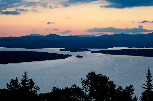
Sunset over Mooselookmeguntic Lake in the Rangeley Lakes Region of Maine
Mooselookmeguntic and Cupsuptic Lake in Rangeley, Maine are actually two bodies of water originally separated by a short, narrow river. They were joined when the water level of Mooselookmeguntic was raised fourteen feet after the Upper Dam was built in 1850.
Together, the two basins encompass 16,359 acres and have a maximum depth of 139 feet with a mean depth of 60 feet. They offer an impressive 57.5 mile perimeter to explore–full of coves with names like Echo, Wildwood, Sandy and Points named Eagle, Stony Batter and Birch. And there are islands as well, including Toothaker, Farrington, Lunch, Blueberry and Pleasant.
What fish will I catch on Mooselookmeguntic? Sport fishermen have been traveling to Rangeley since the 1860s because of the salmon and brook trout. In fact, many sporting camps were built here. Some are historic landmarks on the lake, including “The Ledges” Camp, Brown’s Island and “Camp Moonahanis,” Bald Mountain Camp (still operating), The Barker Camp and Senator Frye’s Camp. The Rangeley Outdoor Sporting Heritage Museum memorializes and honors the rich fishing and hunting tradition of the Rangeley Lakes Region.
Where can I launch my boat? There are three maintained boat launches on Mooselookmeguntic: On Willson Mills Road on Cupsuptic, South Arm Road near Toothaker Island and at Haines Landing near the end of Route 4.
Are there invasive aquatic plants? Thanks to the fine work of Courtesy Boat Inspectors, it is believed that there are none. Some invasive plant fragments were discovered on a boat trailer, but a search of the lake, which had been previously inventoried, has not shown any growth.
The name Mooselookmeguntic is a Native American term meaning either “portage to the moose feeding place,” or “moose feeding among trees.” The locals refer to the lake as Mooselook. Cupsuptic means “a closed up stream.”
Framed by mountains, e.g. Bald Mountain, Bemis and White, lakefront property owners know that it’s a joy to wake up beside the waterfront of Mooselook each day. The pristine water is inviting and the wildlife viewing–top notch. If you like to waterski, swim, sail, kayak, canoe, hike, hunt, snowmobile or ski, you are in the right place. This is a four-season vacation destination. There are innumerable hiking trails in the area, including day hikes up Bald Mountain, Angel Falls, Cascade Stream Gorge, Round Top and Piazza Rock. The Appalachian Trail is nearby. There are also extensive snowmobile trails in the region. And all-terrain vehicle riders will be happy to know that the Richardson Public Reserve Land, located between Mooselook and Upper Richardson Lake, is one of the few public lands open to ATVs. Downhill skiers will enjoy the slopes at Saddleback, Sandy River and Sugarloaf USA. For Nordic skiers, there are groomed trails at Rangeley Lakes Trails Center.
Mooselook is actually part of the 740-mile Northern Forest Canoe Trail that stretches from Old Forge, New York, across the mountain and lakes regions of Vermont, New Hampshire and Quebec to Fort Kent, Maine.
Step back in time and enjoy a family vacation at your waterfront property on Mooselookmeguntic Lake. Take a lake cruise or seaplane ride, play a round of golf, go for a drive, being sure to stop at the Height of Land, shop in nearby towns and spend endless hours playing in or on the water. Every day that you are at Mooselookmeguntic will be a gift.
To learn more about lakefront property listings for sale on Mooselookmeguntic and Cupsuptic Lake, click on the green box above.
To learn more about other sport fishing lakes, click on the blog links below.
Brewer Lake, Orrington, Holden & Bucksport, Maine: Escape to Lakefront Property
Great Moose Lake in Hartland, Maine: A Destination for Sportsmen and Recreational Travelers

