Maine’s Sebago Lake Land Reserve: A Centerpiece of Recreation and Beauty on the Lakefront
Lakes Environmental Association, Bridgton, Maine, Proposes Lake Science Center
October 3, 2013Out and About for the Bangor Lakes Regions of Maine Oct. 10-16
October 9, 2013Maine’s Sebago Lake Land Reserve: A Centerpiece of Recreation and Beauty on the Lakefront
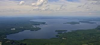
Bird’s Eye View of Sebago Lake, Maine
Lakefront property owners know that Sebago Lake is a centerpiece of recreation and beauty. At twelve miles long, the lake covers 30,000 acres or 45.6 square miles, making it the second largest lake in Maine and third largest in New England.
Its maximum depth is over 300 feet and its mean depth is just over 100 feet. The lake’s 105-mile long shoreline touches the towns of Naples, Casco, Raymond, Windham, Standish, Sebago and Frye Island.
The southern end of the lake, known as Lower Bay, provides drinking water for 15% of Maine’s residents. According to the Portland Water District, this section of the lake has been used as a water supply since the Civil War.
Land around the Lower Bay was purchased to protect the drinking water source. To this end, there is a two-mile no bodily contact zone in the lake and a no trespassing zone within 3,000 feet of the source.
That being said, in 2005 the Portland Water District opened 1,700 acres of land to the public. “It is the policy of Portland Water District to support measures to preserve Sebago Lake watershed land in perpetuity and to provide open space for lake-friendly public access.”
The Sebago Lake Ecology Center serves as the gateway to the Sebago Lake Land Reserve and is the source for educational programs and information on the reserve’s natural communities, flora and fauna.
From the Ecology Center located at the intersection of Routes 35 and 237, you can take a guided tour and learn more about lake-friendly landscaping. Demonstration gardens filled with native plants display ways to reduce stormwater run-off, a major source of water pollution. There is also a library filled with environmental-themed books for young and old.
You may also explore the property on your own. Twelve kiosks dot the property with information about trail use. To use the trails, you must complete a permit at a kiosk. The permits are free. Seasonal and multi-day permits are available from the Ecology Center. Land abutters may obtain an annual visitors pass by contacting the Environmental Services Department at 207.774.5961, ext. 3323.
Activities allowed on the trails include the following: walking, hiking, mountain biking, horseback riding, hunting, skiing, snowmobiling, fishing, trapping, snowshoeing and berry picking. ATVs and motorcycles are not allowed. Nor are camp fires or camping.
The trails also connect to the Sebago to the Sea Trail and the Mountain Division Trail. On the reserve, you’ll have the opportunity to observe wildlife, see several different natural communities of trees and plants, as well as evidence of previous glacial activity. Between the Bobcat and Horsetail trails, for instance, a steep slope known as a kame slope was formed by glacial deposits. The Otter Ponds, accessible from the Mallard Trail, are kettlehole depressions.
The next time you’re looking for something to do, we strongly encourage you to head to the Sebago Lake Land Reserve.
To learn more about lakefront properties for sale on Sebago Lake, click on the green box above.
To learn more about the Sebago Lakes Region, check out the blog links below.
Sebago Lake Region, Windham, Maine: Lakefront Property Highly Valued
Standish, Maine: Family Boating Featured at Richardson’s Boat Yard on Sebago Lake
Places to Picnic in the Sebago Lakes Region of Maine