Hikes In and Around Bethel, Maine

Peabody Pond Lakefront Property a Piece of Paradise in Sebago, Maine
December 20, 2012
Out and About for the Mid Coast Lakes Region of Maine Dec. 27-Jan 2
December 26, 2012Hikes In and Around Bethel, Maine
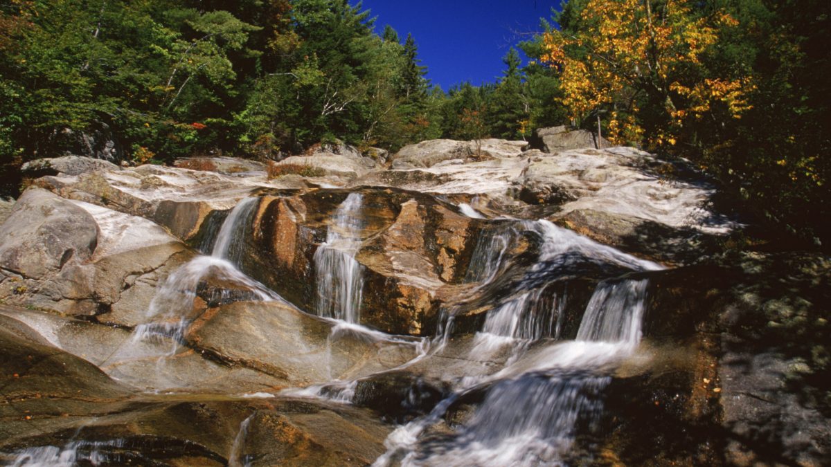

Step Falls Nature Preserve just north of Bethel, Maine
Bethel, Maine is a historic village located near the Androscoggin River and only minutes from Sunday River Ski Area and Grafton Notch in the White Mountains. It’s an “outdoorsy” kind of town and many people spend time on the trails.
Walking Tour of Historic Bethel: Within the village there are 39 homes, Inns, churches, halls and other sites that date from 1774 to 1920. The Bethel Historical Society has produced a brochure for those who wish to take the self-guided walking tour. The brochure is available at the Bethel Area Chamber of Commerce. Directions: 8 Station Place, Bethel. Degree of Difficulty: Easy.
Bethel Pathway: Along the Androscoggin River is the 1.5 mile Bethel Pathway. This paved pathway meets ADA standards and was built for walkers, bikers, roller bladers, runners, skateboarders, snowshoers, cross-country skiers and those in wheelchairs. You’ll also find a skatepark, playground, covered picnic tables and boat launch at Davis Park. Eventually, it is hoped that the trail will extend from Telstar High School to Artist Bridge over Sunday River in Newry. Directions: Davis Park on Route 26. Degree of Difficulty: Easy.
Mount Will: The 3.3 mile loop up and around the 1,736-foot Mount Will begins with a nature trail. The natural history of local flora and fauna is explained on plaques along the first section of the trail. Views from the ridge include the Androscoggin River Valley and Bethel Village. Directions: Route 2, opposite Bethel Recycling and Transfer Station. Degree of Difficulty: Moderate.
Step Falls Nature Preserve: Located along Wright Brook, the preserve includes the 135-foot cascades and chutes. Step-like ledges entice young and old to dip their feet into the cool mountain water, break for a picnic lunch and pose for photographs. Directions: Route 26, 8 miles north of Bethel Village. Degree of Difficulty: Easy.
Grafton Notch State Park: There are impressive waterfalls and gorges that are within easy reach from pull-in sites along Route 26 (the Grafton Notch Scenic Byway). This area is also home to 12 of the most challenging hikes along the Appalachian Trail. The Mahoosuc Range offers spectacular views and rugged terrain for backcountry hikers and skiers.
Degree of Difficulty for the following: Easy/Moderate. Do supervise children.
Screw Auger Falls: A 23-foot waterfall lying in a narrow gorge along the Bear River. Mother Walker Falls: This V-shaped gorge is more than 40 feet and 980 feet long.
Moose Cave: A 200-foot-long gorge, lying within a 45-foot-deep canyon.
Degree of Difficulty for the following: Challenging. Be prepared.
Grafton Loop Trail: (38 miles, 3 or more days) A high-elevation, backcountry trail with seven primitive campsites, connecting a series of nine scenic peaks, including Old Speck, Sunday River Whitecap, Puzzle Mountain, and East and West Baldpate.
Old Speck Trail: (7.6 miles, 7 hours) Spectacular views from an open observation tower at the summit. Follow the white-blazed Appalachian Trail south along Cascade Brook. The summit and tower are reached via a 0.3-mile spur.
Eyebrow Loop Trail: (2.2 miles round trip, 2-3 hours) This trail rises steeply to an “eyebrow” overlook on Old Speck Mountain at 2,900 feet. Follow the white-blazed Appalachian Trail south for 0.1 miles to the start of the orange-blazed Eyebrow Trail.Portions of the climb involve ladders/steel rungs: the descent following the Appalachian Trail is steep but involves no climbing. To avoid the rungs and ladders you can ascend and descend via the AT portion for a 2.6-mile roundtrip.
Table Rock Loop Trail: (2.4 miles round trip, 2 hours) Follow the white-blazed AT. After 0.1 miles, decide between the steep, boulder-strewn, orange-blazed Table Rock Trail or continue on the moderately steep AT to the next junction. After approximately one mile, the blue-blazed Table Rock trail begins. Table Rock offers fantastic views to Old Speck, the Eyebrow and Grafton Notch.
Baldpate Mountain Trail: (5.8 miles round trip to West Peak; 7.6 miles round trip to East Peak; allow 7 hours round trip) Follow the white-blazed AT north, crossing Route 26. The trail ascends steadily across the north slope to the open summit of West Baldpate (elevation 3,680 feet). Turning, the trail dips 240 feet before climbing to East Peak, nearly a mile beyond. East Peak (elevation 3, 812 feet) offers outstanding views in all directions.
Appalachian Trail: (20+ miles, 4 days) The steep, boulder-strewn trail follows ridgelines through the Mahoosuc Range, with the most difficult stretch between Full Goose Lean-to and Speck Pond Lean-to.
Refer to the AMC Maine Mountain Guide and/or the Maine Appalachian Trail Club’s Guide to the Appalachian Trail in Maine for more details on hiking routes along the AT.
Sunday River Ski Area: Hikes for a variety of abilities can be found here.
Maine Road: This 2.7 mile walk begins at South Ridge Lodge and continues on to the base of Aurora Peak or Jordan Bowl. Degree of Difficulty: Easy.
Lolapalooza: Beginning at the Jordan Grand Hotel, follow the Lollapalooza ski trail to the top of Jordan Bowl. Enjoy incredible views of the Mahoosuc Mountains and White Mountains. Degree of Difficulty: Difficult
Way Outback: Beginning at the Jordan Grand Hotel, follow Maine Road down the Lollapalooza ski trail. Turn left just before the Jordan Bowl Express lift and walk along the dirt road back to Monkey Brook Road and the hotel for a one-mile round trip. Degree of Difficulty: Easy.
Three Mile /Jungle Road: This two-mile hike leads from the Peak Lodge on North Peak, along the Three Mile ski trail to the top of Barker Mountain.Degree of Difficulty: Moderate
Ravine Trail: Begin at the Grand Summit Hotel or from the Maine Road trail and hike in either direction. Pass through wooded sections exclusive for hikers–be sure to follow the trail signs for this 2.5 mile hike. Degree of Difficulty: Difficult
To learn more about lakefront properties for sale in the Bethel area, click on the green box above.
To learn more about Songo Pond and other waterbodies near Bethel, check out the blog links below.
Buy a traditional Maine Waterfront Cottage on Songo Pond near Bethel, Maine
Concord, Little Concord and Shagg Ponds in Woodstock, Maine, Offer Remote Getaway Destinations